Hello, again. This
is going to be one my longer blogs so you might want to take a minute and get a
beverage, go to the bathroom, kick off your shoes, and get comfortable. This weekend I drove the Georgia Military
Highway from Tbilisi to the Russian border.
First, some background: The
Georgia Military Highway (GMH) was established as a trade route in the 1st
century BCE. The Russians developed it
into a carriage road in 1783 through the labor of over 800 soldiers, an
incredible number at the time to be dedicated to simply building a road. It was the primary trade route from the Black
Sea to Russia and north until 1883 when a railway opened from the Black Sea to
Moscow. About 100 years later, the Roka
Tunnel opened in what is now South Ossetia and the Gori-Tskhinvali road became
the major north-south thoroughfare until the 2008 war.
The GMH is still an important route from Tbilisi and
central Georgia to the northern slopes of the Caucasus Mountains, at least in
the summer months. This is the route,
all 138 kilometers of it (85 miles, give or take), that I decided to drive this
weekend. The primary feature of the
road, other than the mountains, is the Aragvi (Uh-rug-wee) Rivers and the
mountain streams that flow into them.
The first stop was at a church in Tsilkani, a 5th
century basilica that is one of the oldest churches in the country. It’s famous for its icon of the Virgin Mary
allegedly painted by St. Luke on a board from Christ’s cradle. I don’t want to appear skeptical, but I think
the paint was still wet last weekend. I’ll
let you be the judge. Whatever you think
of the painting’s provenance, the church is impressive and a local point of
pride.

A short drive took me to Ananauri (Anna-nor-ee), an
amazing church complex on the farthest point of the Zhinvali Reservoir. The larger church was completed around 1689,
and has one of the most unusual carvings anywhere: a huge cross standing on the back of two
dragons, flanked by two vines being eaten by deer above two angels with
moustaches and two lions. The carving is
a combination of Christian, Persian, and pagan influence, but is unfortunately
situated so close to the outside wall it’s hard to get any kind of framing for
a picture. Here’s the best I could do,
and that picture cost me my sunglasses as they slipped off the top of my head
while I climbed a short wall, balanced on one foot, and took the picture.


This picture was taken from the guard tower and overlooks
the lake and the two churches. Finally,
the bell tower, also built sometime in the 17th century, houses a
secret underground room, accessed by the steep and narrow stairs shown below, where
soldiers hid before rushing out to attack intruders.


The road continues to a town called Pasanauri
(Pass-a-nor-ee), a town of literally two streets: one runs northbound and the other southbound,
separated by an island of houses and small markets. The interesting facet of this town is the
confluence of the White Aragvi and Black Aragvi Rivers. The waters of the Black Aragvi are darker
than the waters from the White Aragvi, and the contrast as they flow side by
side can be seen from the banks.


It’s about this time that I started running into the
little roadside stands selling everything from local fruit and produce to woolen
socks and sheepskin hats. Many of these
mini-entrepreneurs actually live and sleep next to their merchandise, as you
can see in the photo below.


This region is also famous for its free-range cattle,
which go wherever they want. They seem
to want to spend most of their time chewing their cud on the bridges that span
the rivers and streams. There’s a
constant breeze blowing along the stream beds, keeping the bugs off the
cows. Unfortunately, they tend to hog
the road, and the only way to get through the herd is to pay a boy a lari
(about 60 cents) to walk in front of your car and shoo the cattle out of the
way. Of course, once you’re past, the
cattle go right back to what they were doing.
Everyone wins – the cattle are insect-free, the local children make a
few bucks, and I get to take interesting pictures.

The streams themselves are fascinating along the
GMH. Take this one, for example:


The water is so rich with iron that it colors the pump
and surrounding rocks with a dark red tint.
It also stains red and pink the chins of the local cattle as the iron
soaks into their “beards” as they drink.
No picture of that, though, as cows apparently don’t like foreigners
shoving a camera in their faces. That’s
another story, and picture, for another time, though, and is going to cost you
at least one beer to hear.
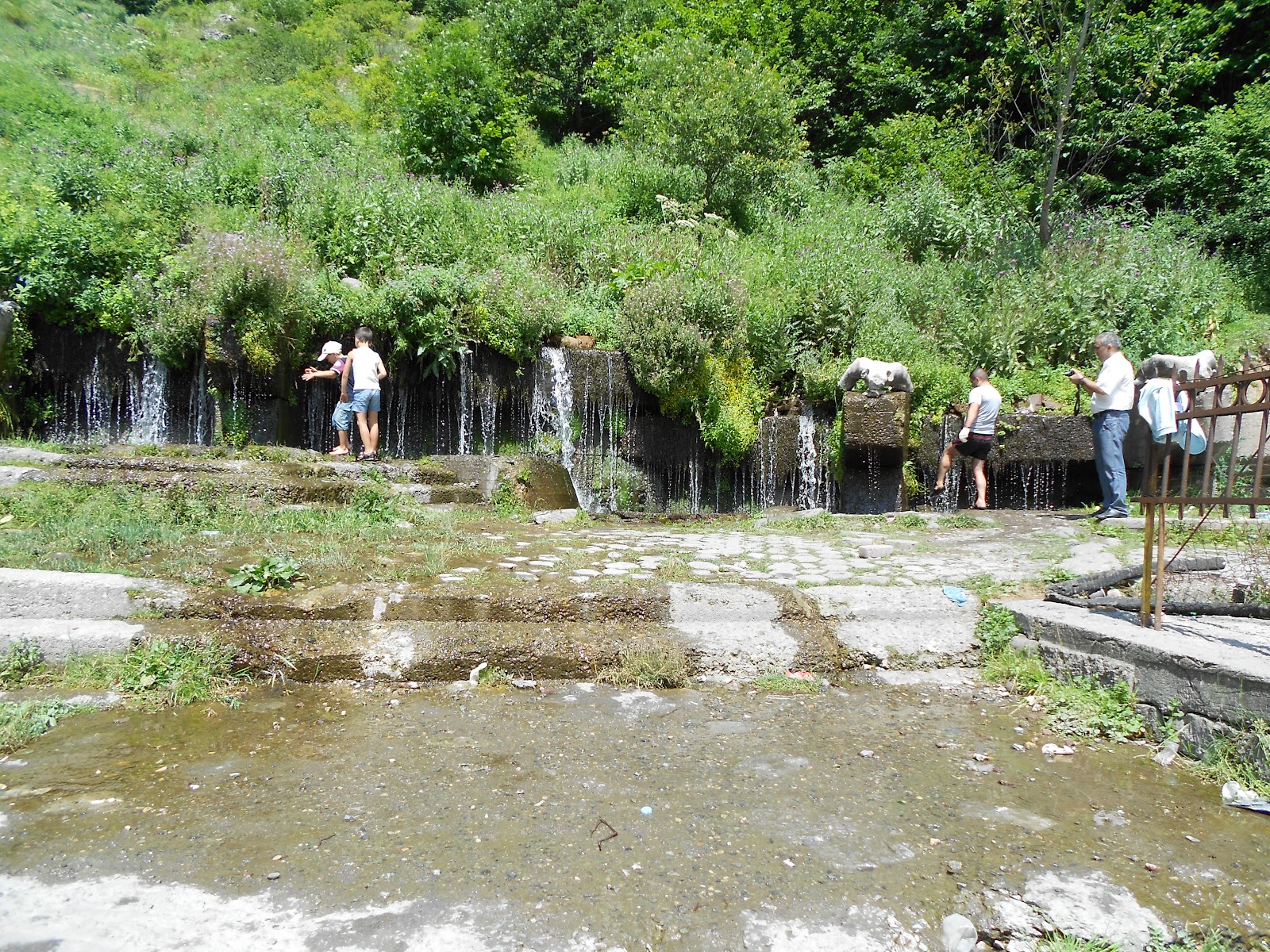
There are also a number of waterfalls, all of them ice
cold with water so pure you can drink directly from the waterfall. You’ll also notice in these pictures a large
snow bank, still present in late July.


The last metal to make an appearance in the local waters
is calcium. This picture shows the “calcium
falls,” formed when the calcium is leeched from the streams. Yellowstone Park in the US has similar
formations. Don’t drink this water,
though; it takes terrible and is warm.


Leaving the town of Gudauri (good-or-ee) I ran into a
local beekeeper selling honey from a semi-trailer which served as home for his
hives and his living quarters. I
pantomimed to the man that I, too, am (or at least was) a beekeeper and he gave
me a tour of his hives, all amazingly strong and healthy. We stood in the back of his
trailer/hive/home, and discussed the finer points of beekeeping, again mostly
through pantomime as the man spoke only Russian even though he is Georgian by
birth (not uncommon in this region; Russian is the first language for at least
half of the Georgians living here).
After purchasing a kilo of his finest honey ($8 for 2 pounds of the
sweetest and lightest honey you’ll ever find), we consummated our deal (but
certainly not our relationship) with two shots of chacha (pronounced zha-zha,
like the second “g” in garage), a national spirit made from fermented grape
skins and similar to Italian grappa. I’ve
had experience with chacha before (to my eternal regret), but this time managed
to keep the toasts down to a minimum as I had to drive.


After a six-hour drive (and remember, the road is only 85
miles long), I entered the town of Stepantsminda (known in Russian as Kazbegi),
only 15 miles kilometers from the Russian border. The drive took so long because I couldn’t
resist stopping at every spot that gave me a view of the mountains and
valleys. One in particular will stay
with me forever. It’s a rock that hangs
over the sheer side of the valley, about a 1000 foot drop to the streambed
below. You stand on that rock, with the
wind blowing, looking down at a positively fatal fall, and the adrenaline
definitely flows.


Stepantsminda (St. Stephens, pronounced Step-aunts-minda),
or Kezbegi if you prefer (Kaz-beck-ee), has some of the most awe-inspiring
views of the Caucasus you’ll ever see.
The weather was misty, unfortunately, but you still get the idea. I spent $35 and rented a room with breakfast
at the local hotel. The room was the
size of a jail cell, so small that the 10” TV sat on a nightstand since the
room was only large enough for a bed and nightstand. It was, however, clean and friendly (more
than I can say for the kitchen staff).
Breakfast was of the European variety – bread, lunchmeat, locally made
yoghurt, granola, and smoked fish. What –
you don’t eat smoked fish for breakfast??
Yeah, me, neither. Since I was
obviously identified as American, though, the cook managed to scramble up some
eggs and fry some sausages to go along with Russian black tea – very strong and
hot. I’m a fan.

After my filling breakfast, I hiked 7 kilometers to a
monastery near Mount Kazbek, the highest peak in the Caucasus at 5100 meters
(almost 17,000 feet). The large,
mist-covered peak in the background is Mount Kazbek. The monastery, as I said, is a 7 kilometer hike,
about 4.5 miles. It takes over 2 hours
to hike up and about 10 minutes to sprint down.
It’s one steep SOB, I’ll tell you that.
And at the top is a working monastery, none too friendly it happens,
especially to women. Women visiting are
required to change into dresses and are hissed at by the monks if they dare
speak inside the church. I’ve never seen
that anywhere else in Georgia, and it was a bit upsetting, so I hiked back down
to Stepantsminda for another beer or 12.


This trip was everything I love about Georgia – historic,
quaint, rustic, and filled with warm and friendly people – and I can’t wait
until my next roadtrip. Thanks for
reading.


No comments:
Post a Comment